| Mahaboboka | |
|---|---|
 Mahaboboka Mahaboboka | |
 | |
| Coordinates: 22°54′S 44°20′E / 22.900°S 44.333°E / -22.900; 44.333 | |
| Country | |
| Region | Atsimo-Andrefana |
| District | Sakaraha |
| Elevation | 313 m (1,027 ft) |
| Population | |
| • Total | 13,115 |
| Time zone | UTC3 (EAT) |
Mahaboboka is a town and commune (Malagasy: kaominina) in Madagascar. It belongs to the district of Sakaraha, which is a part of Atsimo-Andrefana Region. The population of the commune was estimated to be approximately 13,115 in 2018.
Primary and junior level secondary education are available in town. Mahaboboka has a police station, an Orthodox Church and a mosque. Traditional graves can be seen close to the road around Mahaboboka. The majority 80% of the population of the commune are farmers, while an additional 10% receives their livelihood from raising livestock. The most important crop is rice, while other important products are cassava and sweet potatoes. Services provide employment for 8% of the population. Additionally fishing employs 2% of the population.
Geology
West of the Ilova fault, the Sakaraha–Toliara road crosses upper Jurassic marls and limestones. To the north, they have yielded ammonites, and to the north-west, they are succeeded by Cretaceous sedimentary rocks and basalts.
Economy
Natural gas has been discovered in Mahaboboka in 2016.
Also minerals, as sapphires are found at Mahaboboka.
Rivers
Mahaboboka lies at the Fiherenana River.
-
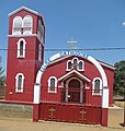 Orthodox church in Mahaboboka
-
 Traditional graves near Mahaboboka
-
 Typical landscape near Mahaboboka
-
 Typical vegetation near Mahaboboka


References and notes
- Estimated based on DEM data from Shuttle Radar Topography Mission
- "ILO census data". Cornell University. 2002. Retrieved 2008-03-25.
- Besairie & Collignon (1972). "Géologie de Madagascar. 1. Les Terrains sédimentaires".
- GondwanaFossils. "Where in Madagascar do large Jurassic ammonites come from ?".
- (in French) www.midi-madagasikara.mg
| Capital: Toliara | ||
| Ampanihy Ouest (19) - 605 |  | |
| Ankazoabo - 606 - (10) | ||
| Benenitra - 610 - (6) | ||
| Beroroha - 611 - (9) | ||
| Betioky-Atsimo -612 - (31) |
| |
| Morombe (9) - 618 | ||
| Sakaraha (12) - 620 | ||
| Toliara I (1) | ||
| Toliara II (22) (602) | ||
| 9 districts; 119 communes | ||
22°54′S 44°20′E / 22.900°S 44.333°E / -22.900; 44.333
This Atsimo-Andrefana location article is a stub. You can help Misplaced Pages by expanding it. |